The Remote Lens Reshaping Modern War Correspondence
War reporting once depended heavily on physical access. Correspondents travelled with military units, waited for official briefings, cultivated local sources, and tried to interpret events through the narrow windows created by censorship, danger, and distance. Today, a newsroom can begin investigating a reported strike within minutes by combining commercial satellite imagery, social media posts, flight tracking, historical maps, and publicly available databases. This does not make frontline reporting effortless, but it changes who can challenge an official account and how quickly that challenge can be assembled.
Open-source intelligence, or OSINT, has become central to that transformation. Investigative groups and specialist desks can compare a government statement with visible damage, identify a runway or building in a video, and reconstruct the sequence of an attack without entering the combat zone. Resources such as Bellingcat”s investigations and research guides have helped popularize methods once associated primarily with intelligence agencies. Commercial Earth observation companies have also made parts of the battlefield visible to journalists, humanitarian organizations, and the public.
The promise is substantial. Satellite evidence can expose demolished neighborhoods, destroyed infrastructure, altered military positions, and the physical aftermath of attacks that officials deny or obscure. Yet remote analysis has limits that are easy to overlook. A pixel can show a crater but not the fear inside a shelter, a damaged road but not the people unable to reach a hospital, or a destroyed building but not the history of those who lived there. The modern challenge is therefore not choosing between technology and traditional reporting. It is learning how to make each correct the weaknesses of the other.
From Fog of War to Public Pixel
For much of the twentieth century, frontline journalists operated within an information system controlled by access. Military authorities determined which reporters could travel, what they could see, and when they could transmit material. Embedded reporting could provide valuable proximity, but it also placed journalists inside a particular chain of movement and security. Independent reporters outside that system faced checkpoints, censorship, unreliable communications, and serious physical danger. Official spokespersons consequently remained powerful sources, even when their claims were disputed.
Commercial satellite imagery has changed the evidentiary balance. Providers can collect repeated images over the same location, allowing analysts to compare conditions before and after an attack. Optical imagery may show collapsed structures and burned areas, while synthetic aperture radar can detect changes even through cloud cover or at night. Historical imagery tools, including Google Earth, allow investigators to compare building shapes, roads, terrain, and landmarks across time. As explained in Bellingcat”s geolocation methods, distinctive structures and 3D terrain can help establish where an image was recorded and which direction the camera faced.
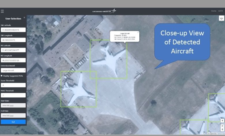
The transformation is best understood as a change in reporting friction rather than a complete removal of uncertainty.
| Reporting stage | Earlier conflict coverage | Modern open-source workflow |
|---|---|---|
| Initial claim | Official briefing, witness account, or correspondent dispatch | Official claim combined with posts, videos, maps, and alerts |
| Location check | Reporter”s physical access and local contacts | Landmark matching, terrain analysis, mapping, and satellite comparison |
| Damage assessment | On-site observation, often delayed by security restrictions | Repeated commercial imagery, radar data, and before-and-after analysis |
| Publication | Editor evaluates limited and sometimes conflicting testimony | Newsroom documents source chains, timestamps, geolocation, and uncertainty |
This pipeline does not automatically produce truth. It produces more opportunities to test claims. OSINT platforms bring together television, radio, social media, websites, imagery, and archival material, while professional analysts add language skills, geospatial expertise, and source evaluation. The result is a more distributed form of verification in which a newsroom, a volunteer researcher, or a specialist collective may identify contradictions before governments or established institutions respond.
Corroborating Ground Realities with Digital Traces
A reliable investigation rarely rests on a single image. Reporters compare independent traces that were created for different reasons and therefore may be harder to manipulate in exactly the same way. Flight radar data can indicate whether aircraft were operating near an alleged strike. Shadows in a social media video can help estimate the time of recording. Road layouts, rooflines, utility poles, hills, and other fixed features can connect a short clip to a precise location. SAR imagery can reveal changes where conventional photographs are unavailable or obscured by weather.
Modern investigative collectives have made this approach more systematic. Newsrooms increasingly adopt rigorous digital investigation workflows developed by open-source research networks, combining technical tools with transparent documentation. The aim is not to produce a visually persuasive theory, but to show how each conclusion was reached and where uncertainty remains.
- Preserve the original material. Save the video, image, post, URL, publication time, account details, and available file information before content is deleted or altered.
- Establish the chronology. Compare upload times with local time, known explosions, air-raid alerts, weather conditions, and satellite acquisition dates. Publication time is not necessarily recording time.
- Test the location. Match visible landmarks, road intersections, building arrangements, terrain, and skyline features against satellite maps and historical imagery.
- Check the physics. Examine shadows, sun angle, smoke movement, blast direction, crater shape, and damage patterns. These clues can support or undermine a proposed time and location.
- Seek independent confirmation. Compare the result with radar records, additional footage, local reporting, humanitarian updates, and imagery from another provider. Publish the limits as well as the findings.
Metadata can be useful but must be treated cautiously. Camera files may contain timestamps, device information, or geolocation data, but social platforms often strip metadata during upload. A file can also carry incorrect clock settings or be edited without obvious visual signs. The absence of metadata is therefore not proof of fabrication, just as its presence is not proof that the file depicts what it claims.
Visual matching is similarly powerful and fallible. Sun angle calculations can narrow a recording window, but obstructions, seasonal variation, and inaccurate orientation can distort the result. Topographical matching can identify a valley or distinctive ridge, yet similar landscapes may exist in multiple places. The strongest investigations explain the chain of reasoning, cite the original material, distinguish direct observation from inference, and invite independent review.
The Gatekeeper Dilemma and Commercial Censorship
The democratization of imagery has created a new dependency. Much of the most useful high-resolution satellite data is owned by private companies whose customers include governments, defense agencies, insurers, investors, humanitarian groups, and news organizations. Those companies operate under national laws, contractual restrictions, export controls, and commercial incentives. Access can therefore change abruptly even when public interest in an event is at its highest.
A recent case illustrates the problem. The BBC reported on Planet”s restrictions affecting imagery of Iran and much of the Middle East, following what was reported as a request from the United States government. The company moved from a temporary 14-day delay to an indefinite form of managed distribution, releasing selected images individually while limiting broader access. BBC Verify found that the impact extended across much of the region, including Iraq, Lebanon, Israel, and Gaza. Humanitarian organizations said restricted imagery complicated damage assessment, evacuation planning, aid logistics, and documentation of harm.
- Access may be delayed precisely when rapid verification matters most.
- Corporate contracts can create incentives to accommodate powerful government customers.
- Opaque restrictions make it difficult to know whether missing imagery reflects technical limits, security policy, or political pressure.
- Alternative providers may offer lower resolution, less frequent coverage, or different geographic gaps.
- Information blackouts can encourage the circulation of counterfeit or misleading satellite images.
This is not simply a dispute over convenience. If journalists depend entirely on a small group of vendors, editorial independence becomes partly dependent on corporate decisions made outside the newsroom. Greater competition may reduce that vulnerability, but fragmentation can also make verification harder. The public interest requires clearer disclosure about access policies, retention, delays, and the circumstances under which imagery is withheld.
Ethical Hazards and the Myth of Objective Pixels
Open-source evidence can support accountability, but it can also create direct risks. Publishing the location of a damaged facility may help document an attack, yet publishing the location of a temporary shelter, evacuation route, medical site, or vulnerable community can expose civilians to further harm. Combining several harmless-looking datasets may produce a dangerous result, a phenomenon often described as the mosaic effect. The International Committee of the Red Cross has warned that harm can arise during the collection, retention, analysis, or publication of conflict data, not only at the moment of release.
There is also a legal and moral difference between documenting violence and enabling it. Publicly available information can be used by militaries, armed groups, propagandists, investigators, and journalists. In conflicts where civilian analysts track artillery positions or troop movements, a newsroom must consider whether publication could function as targeting assistance. International humanitarian law provides important protections, including for medical information, but the legal treatment of civilian data operations remains complex. Privacy and data protection principles may offer additional safeguards, although their application during armed conflict is not always clear.
- Remove precise locations when they could expose civilians, medical workers, or displaced people.
- Delay publication when real-time disclosure could affect an ongoing operation or evacuation.
- Separate evidence needed for public accountability from details that add curiosity but increase risk.
- Consult local journalists, humanitarian specialists, and affected communities before publishing sensitive material.
- Record chain of custody and analytical uncertainty so that evidence is not overstated.
Pixels also lack human context. Satellite imagery can reveal a roof destroyed between two dates, but it cannot establish who was inside, whether an evacuation order was received, or how survivors experienced the event. A geolocated video can show a street but may not explain the identities, intentions, or relationships of the people visible in it. Human sources and witness testimony remain essential because they supply meaning, motive, chronology, and accountability that remote sensing cannot provide.
Balancing Digital Forensics with Human Truth on the Ground
The strongest war reporting treats satellite imagery and metadata as part of a wider reporting system. Digital forensics can test official claims, identify patterns, and protect journalists from repeating unverified allegations. Shoe-leather reporting can establish what happened to individuals, reveal consequences invisible from above, and expose the assumptions built into technical analysis. Together, these methods create a stronger record than either could produce alone.
Readers evaluating visual evidence should ask several practical questions: Who obtained the material? Is the date known or inferred? Has the location been independently established? Are there competing explanations? Does the analysis distinguish a confirmed fact from a probability? Has the report included local testimony and acknowledged what the image cannot show?
- Prefer evidence with a transparent source trail over anonymous screenshots.
- Look for corroboration from unrelated data sources.
- Treat dramatic imagery without location, date, or provenance as unverified.
- Be cautious when a conclusion appears more certain than the underlying evidence.
- Watch whether corrections and methodological details are published openly.
The next challenge will come from synthetic media and increasingly automated analysis. AI-generated images, altered satellite scenes, automated captions, and convincing fabrications will complicate both verification and public trust. Machine learning may accelerate comparisons across enormous archives, but it cannot replace accountable editorial judgment. The durable standard is therefore clear: use technology to widen the field of evidence, keep human reporters close to affected communities, and make every important conclusion traceable, contestable, and honest about uncertainty.